 Back to the Future History Page
Astronomy in Pournelle's Future History

Galactic Map
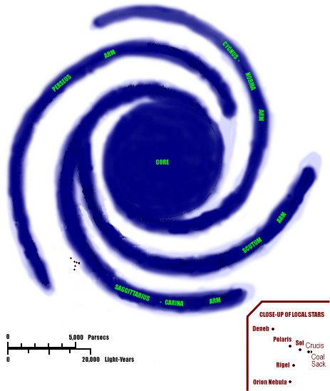
This map of our galaxy (the "Milky Way") is based on the one in the 1994 Cambridge Atlas of Astronomy. All star positions are taken from the Gliese Catalog of Nearby Stars and various other catalogs.
Very few real astronomical objects are mentioned in Pournelle's Future History series:
- Earth, Luna, and Ceres are the only settlements mentioned in the Solar system. The Grand Senate and the headquarters of the CoDominium Fleet were on Luna in the 2100's. Ceres Base is a small military port-of-call, burrowed into the asteroid. (References in FL 210, 216, and "He Fell into a Dark Hole" 16-19, 37. For details on book abbreviations and page numbers, see the Bibliography.)
- Meiji is mentioned in "He Fell into a Dark Hole", but this story is not consistent on what its star is. On page 24 it is located at 82 Eridani, while on pages 29 and 48 it is in the 81 Eridani system. I have chosen 82 Eridani as the proper location, for the following reasons:
- 82 Eridani is a nearby star (20.44 light-years away), while 81 Eridani is much further away. We know Meiji was settled very early during the Great Exodus, and is only two jumps from Sol. So this distance makes sense.
- 82 Eridani is a G5 V star, very similar to our sun (which is G2 V). This makes it a logical place for Meiji, since that colony is a fairly pleasant planet.
-
 The recent story "Pictures of a Floating World" states that Meiji is the fourth planet of 82 Eridani. (WWFCD 84)
82 Eridani is located at 3:19:56 hrs Rt Asc, -43.070° Dec, and has a visual magnitude of 4.27. In galactic coordinates it is at longitude 250.28° and latitude -55.814°. It is 20.44 light-years (6.267 parsecs) from Earth.
On the map above, the dot representing Sol is thick enough that it includes 82 Eridani as well.
- Crucis is the home of the Blaine family from the 27th century until the 31st. However, this planet never enters into any stories directly. It is presumably a star in the constellation Crux (the Southern Cross). But which star?
Alpha Crucis is also named Acrux. And we know that Roderick Harold, Lord Blaine, the heir to the Marquis of Crucis, holds the title "Earl of Acrux" (Hand 58). So it is very possible that "Crucis Court" is on a planet in the Acrux System. But we don't know that for certain; it's possible that the title "Earl of Acrux" is like the title "Prince of Wales" – in other words, it might refer to a different star than the actual home of the Blaine family.
Alpha Crucis can be seen at 12:26:36 hrs Rt Asc, -63.10° Dec, and has a visual magnitude of 1.33. In galactic coordinates it is at longitude 300.47° and latitude -0.609°. It is located around 400 light-years from here. It is a double star. Alpha Crucis A is a B1 V star, blue-white and extremely bright, but not especially large.
This seems a plausible choice for Crucis' location. Stories set in the Trans-Coalsack Sector often refer to the majority of the Empire being on the other side of the Coal Sack, and usually Crucis is referred to specifically. Alpha Crucis is on our side of the Coal Sack but not very far from it. (Of course, a lot of stars in Crux can make this boast!) Also, Crucis is not explicitly mentioned in any stories until the Secession Wars, and House Blaine probably dates from this era (see the Timeline for details.) So its distance is plausible; we know humanity reached the Coal Sack by 2450.
On the other hand, "Crucis Sector" is mentioned in the 2100's, and includes Dayan and other 21st Century worlds. We know little about what determines a "sector". But in any event, there is clearly a Blaine family holding the Acrux system, whether or not that is "Crucis" itself.
- New Chicago is located at "Beta Hortensis" or "Beta Hortensi" (Mote 3, Reflex 16). There is no constellation today with a name similar to this. This isn't surprising, because New Chicago would not be visible from Earth. It may be behind the Coal Sack, and even if it's not, an F9 star near the Coal Sack would be invisible to all but our best telescopes.
- The Coal Sack itself is a dark nebula, centered at 12:50 hrs Rt Asc, -63° Dec, and stretching across 6° of the southern sky. It spans from Galactic Longitude 300° to 306° and Galactic Latitude -4° to 2° (very close to the galactic plane). The Coal Sack is about 550 light-years from Earth. Niven and Pournelle put Murcheson's Eye behind the Coal Sack because they wanted a fairly nearby red giant star, didn't believe any known giants were close enough, and so imagined a red giant just behind the Coal Sack that would be relatively close to us but invisible from the Earth. However, the most recent figures suggest that Antares is probably about the same distance from us as the Coal Sack. It is possible that when Mote was written, the authors believed Antares to be farther than it is, or the Coal Sack to be nearer than it is.
Galactic latitude and longitude give an object's position from Earth's perspective. The core of the galaxy is at 0° latitude and 0° longitude, at a distance of around 30000 LY. Due "north" along the galactic axis is latitude +90°.
There are over 100 000 000 000 stars in the Milky Way Galaxy. The Core of the galaxy is an ellipsoid with 5000 LY as its vertical radius and 10000 LY as its horizontal radius. The entire galactic disk has a horizontal radius of 50000 LY; our sun is around 30000 LY from the center.
Thus, leaving Sol and heading through Sagittarius, it is 20000 LY to the edge of the Core and another 10000 to the galactic center; heading through Gemini it is around 20000 to the horizontal edge of the galaxy. But one can leave the galactic disk by heading "vertically" a mere 1500 LY.
Note from the map that our sun isn't actually in the local (Sagittarius) arm. But the spaces between the arms still contain stars. As David Gerrold once commented, trying to pinpoint the precise "edge" of the galaxy is like trying to bisect a sneeze. We will merely see a gradual increase in the distance between stars as we "leave" the galaxy.
The motion of stars in a galaxy is very odd – the stars rotate about the center of the galaxy at a much different rate than the spiral arms rotate! Think of the stars as cars, and the arms as "traffic jams" on a freeway – the speed at which the "jam" moves doesn't match the speed of any car. If you're interested in the details, take a look at Binney and Tremaine's Galactic Dynamics.
Map of Known Stars
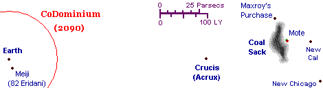
This map shows Sol, 82 Eridani (Meiji), Acrux (Crucis?), and the Coal Sack. Their locations were already described above. The map's scale is correct with regard to these objects.
The additional stars on this map are not identified with any stars known today:
- Murcheson's Eye is behind the Coal Sack, only two light-years from the Coal Sack itself (Mote 155). Note that the Coal Sack's border is probably quite imprecise from close-up, though Dr. Buckman doubtless has a rigorous definition of where it "begins". The Coal Sack itself is about 60 light-years "wide" (along galactic longitude and latitude). Mote 47 and Motelight 115 make it about 30 light-years thick (i.e., in the dimension we can't see from Earth).
- The Mote is very close to the Eye; the precise distance of one-third of a light year is given in "Building the Mote in God's Eye", on page 129 of A Step Farther Out.
- The New Caledonia system, which contains both New Scotland and New Ireland, is 35 light-years from the Mote. (Mote 42, 47, 105; "Building the Mote" 123)
- New Chicago is around 65 light-years (20 parsecs) from New Cal.
- Maxroy's Purchase is close to the Coal Sack, on "our side" or near the edge. Hand 9 makes it clear that a direct line from Maxroy's Purchase to the Mote goes throught the Coal Sack itself.
These distances aren't enough to triangulate the precise positions of these stars. But using these distances and the map in Gripping Hand, they can be plotted within a reasonable degree of error. Note that I have, for simplicity, assumed that these lie somewhat in a plane; by letting them move towards and away from the viewer (galactic north and south) the apparent map-distances could be reduced.
The "CoDominium 2090" border reflects the 200 light-year diameter of the CD mentioned on FL 297. More on this later.
Map from Earth to Sparta

This map shows a closer view of the neighborhood of Sol. The scale of this map is speculation, other than the distance from Sol to 82 Eridani.
The tricky part lies in the fact that Alderson jumps are of varying size. Sparta is six jumps (and six or seven months) from Earth, and Tanith is one jump and one month from Earth (for sources, see below). Meiji is 20 LY from Earth, and (by the ideal route) only two jumps. As a reference for comparison, we may note that (elsewhere in the galaxy) Prince Samual's World and Makassar are 12 LY apart and only one jump apart.
So I've allowed around 10 to 15 LY to each jump on this map, although this is clearly not going to be always the case. (According to WWPW 34, as of 2091 the longest jump ever acheived was 42 LY, and the context makes it clear this was an unusually long jump. According to WWFR 239, jumps are typically between 5 and 15 LY, and almost never longer than 35 LY.)
Green lines represent single jumps. Blue lines represent one or more jumps: this simply means there is a fairly direct "route" between these two stars, but the number of jumps is unknown.
The usual route from Meiji to Earth involves several jumps and passes by Colby. The "direct" route involved exactly two jumps, stopping off at A-7820 (presumably a red dwarf or other uninteresting star) on the way. ("He Fell into a Dark Hole" 18, 21, 24)
The stops from Earth to Sparta are explicitly given on GTS 149 (Prince 717).
Tanith is on the standard routes from Sparta to Earth and from Sparta to New Washington. (See below for more details on New Washington's location). Coming from the Earth, the worlds of Haven, Frystaat, and Dayan are "beyond Sparta". (GTS 94, 149; Prince 679, 717) Crucis is probably also in this direction, since Dayan (later known as Dyan) is in Crucis Sector. (WWI 362)
Distances and travel times
There are frequent mentions of travel times and distances in the Future History books. For the most part they are consistent. This allows us to categorize planets based on their proximity to Earth.
In what follows, all travel times are for normal transit during the 21st century unless otherwise specified. The fastest military ships can sometimes cut these travel times in half (PS 166; Prince 986; WWJ 192) due to their faster speed, and due to the fact that ordinary ships must choose a route that passes near refueling stations, whereas certain military ships get more light-years to the tank (Prince 975). It is also stated that "the fastest messages" can travel in half the time (PS 8; Prince 870) -- but this seems too slow, for a series of messaging lasers sent between small ships stationed next to Alderson Points could be extremely quick, and this would explain how the messages about the "Rump Senate" coup travel from Earth to Sparta in a mere two months (March to May 2096).
The following worlds are relatively close to Earth (a month or two away). All of them were settled during the 21st century.
- Tanith and Stalin are "the two closest habitable worlds to Earth" (WWI[2nd] 196), although it's not clear whether "closest" refers to Alderson travel time or geometric distance.
- There are two routes from Earth to Tanith. One of them is a single jump, but it goes through one of the most distant Alderson Points in the Solar System (GTS 149; WWFCD 102; WWRW 69, 525). The other involves two jumps, but uses a closer Point to Earth (PM 44-45; WWRW 525). Typically, the two-jump route is faster unless both Tanith and Earth are in the nearer sides of their orbits (WWRW 525).
- The trip from Earth to Tanith takes one (or perhaps two) months, a fact which can be deduced by subtraction: As explained below, the trip from Earth to Sparta passes through the Tanith system and takes six (or perhaps seven) months. The second leg of this journey -- from Tanith to Sparta -- takes five months. Therefore, the first leg of this journey -- from Earth to Tanith -- must take one month (or perhaps two, if the trip from the jump-point to the planet is time-consuming).
- The Stalin system is a single Alderson jump from Earth. In "The Sylph in the Tinderbox", the first leg of the journey (from Earth to the Alderson Point in the Solar system) takes six days; the second leg (from the Alderson Point in the Stalin system to the planet Stalin) is of unknown duration (WWPW 404).
- Meiji is located in the 82 Eridani system, which is 20.44 LY from Earth (as discussed in the Galactic Map section above). It is two jumps from Earth (as discussed in the Map from Earth to Sparta section above).
- The system containing the planet Taisho is one jump from Meiji, and the system containing the planet Showa is also one jump from Meiji. Neither planet is habitable, but in 2101 they were candidates for terraforming. (WWFCD 58-59)
- As noted on the Map from Earth to Sparta, Colby is two jumps from Earth, Markham is two jumps from Earth, and Xanadu is four jumps from Earth.
- Sauron is very close to Tanith (WWI[2nd] 60).
- "The Sylph in the Tinderbox" states that the most common route from Earth to Sauron passes through the Stalin system, and seems to imply that the Earth-to-Sauron journey takes three months (WWPW 390, 416).
- Wayforth Station is a space station built in the Rheingold's Star system, an otherwise useless system made valuable by the fact that it has six Alderson Points (WWCD 11; WWBS[2nd] prologue). It is located in the "Tanith Sector" (WWCD 7). Five of its six Alderson Points lead to habitable worlds, including Sauron, St. Ekaterina, Tabletop, and Comstock (WWBS[2nd] prologue, chapter 32). This puts Sauron two jumps from St. Ekaterina -- a fact that would have tragic consequences during the Secession Wars.
- During the Secession Wars, Gaea was easily reachable from Tanith -- unlike to the trip from Tanith to Sparta, which was long and dangerous (WWII 219). This suggests that Gaea is close to Tanith.
The following worlds are a moderate distance from Earth (three to six months away). All of them were settled during the 21st century.
- Sparta is five jumps from Tanith (see the map above). Travel time from Tanith to Sparta is five months (WWI[2nd] 60).
- Sparta is six jumps from Earth, via Tanith (GTS 149; Prince 717). The travel time from Earth to Sparta is given as "six months" (PS 166; Prince 986) or "seven months" (GTS 71; Prince 662). The six-month figure appears in an almanac table, and is probably more reliable. . It takes a BuReloc ship "eight months" to ship a transportee from Earth to Sparta (PS 23; Prince 881), but these ships would probably be slower than many others.
- Sparta is three jumps from St. Ekaterina (WWBS[2nd] prologue): the text seems to imply that that this three-jump route does not pass through Wayforth Station or Sauron.
- According to Hand 60, the Sparta system has twenty Alderson Points. However, WWII 219 says the Sparta system has twenty Alderson Points, which seems a more reasonable number. (WWFR 237 states that a star system cannot have more than six Alderson points, unless it's a multiple star system, in which case it can have a few more.)
- Burgess is fairly close to Sparta, as the trip from one to the other is relatively quick (WWFCD 293-294.
- Thurstone (the planet containing the nations of Santiago and New Aberdeen) is 20 parsecs (65 light-years) and 3 months from Earth (PM 134-35; Prince 388-89). Thurstone is much closer to Sparta than Haven is to Sparta (Prince 965).
- Arrarat is also 20 parsecs (65 light-years) from Earth, and is in Crucis Sector (FL 53, 125; Prince 52, 110).
- Dayan is apparently "beyond Sparta" from Earth's point of view (GTS 149; Prince 717). But as it is a financial hub for many planets, it is unlikely to be too far from the center of civilization.
- Frystaat is also "beyond Sparta" from Earth's point of view (GTS 149; Prince 717), but its distance is unknown, so it could belong in this category or the next. Frystaat is one jump from the uninhabited GSX-3217 system, which is used for mining (WWPW 32).
- Hadley is quite far out, since the CD used it as a colony world for a while and then abandoned it due to its distance (FL 303; Prince 259). One source implies it is a six-month journey from Earth in a BuRelock ship (WWFR 245).
The following worlds are a significant distance from Earth (seven to eleven months away).
- Diego is seven months from Earth in a BuRelock ship (WWFR 256).
- Churchill is ten months from Earth in a BuRelock ship (WWFR 36).
- Churchill is quite close to Diego, as a navy ship can make it from Diego to Churchill in under two months (WWFR 241-242, 247).
- The route from Earth to Churchill passes via Thurstone and then Friedland (WWFR 38).
- Some commercial passenger ships make a circuit from Earth to Danube to Churchill and back to Earth which lasts eighteen months, but this may involve significant stops during the circuit (WWFR 17).
- Levant is "at least seven months" from Earth. The standard route is seven jumps long, and passes through the Tanith system (WWRW 24, 69).
- Istvan is "more than eight months" from Earth (WWJ 188).
- Makassar is "six months from Earth, even by fast Navy ship" (WWFR 215) , which means it takes much longer than six months at normal speed.
- Prince Samual's World is 12 LY from Makassar. Although Prince Samual's World is not mentioned in any stories set in the 21st century, Makassar was settled during the CoDominium era (GTS 11; Prince 619; WWFR 215), and given their proximity it seems likely that Prince Samual's World was probably settled around the same time. If this is the case, Prince Samual's World must have begun under another name, since its name apparently dates from 2273 when it became a Member Principality of the First Empire (KDS timeline). Dring the 31st Century the trip between Makassar and Prince Samual's World takes about 46 days and involves one jump (KDS 6, 93, 95, 155, 255, 305).
The following are among the farthest colony worlds settled during the 21st century, over a year's journey from Earth.
- Haven, in the Byers' System, is the farthest of all human colonies in the 21st century (GTS 94; Prince 679), and remains un-re-discovered in the 3040's. In one passage, Haven's distance from Earth is given as twenty parsecs (65 light-years), although it is unclear whether this is the direct distance or the distance covered by a ship using Alderson travel (WWI[2nd] 59). In any event, the travel time to Haven is longer than one would guess from its distance alone, as it "lies at the end of several awkwardly linked Alderson Jump Points" (WWCD 7).
- The journey from Earth to Haven typically takes 13 or 14 months for a BuRelock ship (14 months in WWI[2nd] 47, 52; 14 months including a stop at Tanith in WWPW 215). The trip from Earth to Haven is elsewhere stated as slightly more than one year (WWCD 7; WWJ 195; WWFR 76), although this is sometimes rounded to simply "a full year" (GTS 94; Prince 679). It is also stated that the trip from Earth to Haven passes by Wayforth Station (WWCD 11) and by Sparta (GTS 94; Prince 679).
- The story "Sacrifice" describes the journey from Earth to Haven in some detail. The trip from Earth to the Alderson Point in the Solar System takes nine days. From there to Wayforth Station requires several jumps, and lasts about six and a half months, so the total trip from Earth to Wayforth Station lasts seven months. The final leg of the trip, from Wayforth Station to Haven, involves only three jumps, but they are so awkwardly placed that this takes six months. So the total trip from Earth to Haven is thirteen months for a regular ship (WWFCD 310, 312, 316).
- Travel time from Sauron to Haven is almost a year (WWI[2nd] 199: this passage might be read as the time for a round trip, but if so, it's too short).
- The route from Meiji to Haven is described in detail: "The journey from 82 Eridani to the Byers System required over a dozen Jumps. A diplomatic courier or naval man-of-war could make the trip in around seven months, twice as fast as a commercial vessel. Half of that time was spent reaching Wayforth Station. The other half was spent making the final three Jumps to the Byers System. The difference arose because the last Jumps were between awkwardly linked Alderson points. Jumps between stars were instantaneous, however, crossing a star system to get from one Jump point to the next could be very time-consuming." (WWFCD 62-63)
- As mentioned above, military ships can make these journeys more quickly when they choose to do so. The fastest military ship "at full throttle" can get from Earth to Haven in 6 months (WWJ 192; WWFR 74), but this only happens in emergencies, as the Consul-General himself expects his trip to take a year (WWCD 395). Similarly, a military ship can travel from Sparta to Haven in 4 months (WWJ 81) -- which is around half of the usual travel time (based on subtraction: the trip from Earth to Haven passes through the Sparta system, and as noted above it is normally 6 months from Earth to Sparta, and 14 from Earth to Haven).
- In the 2050s, Haven is seven Alderson jumps from the nearest habitable world (WWD 263), and the two inhabited planets closest to Haven by Alderson travel are Levant and Adyta (WWTO 183). It's odd that by the time of The Gripping Hand, Levant has been part of the Second Empire for over a century, while Haven apparently remains unknown. Perhaps the Alderson geometry shifted over the centuries... or perhaps some thirty-first century Levantines actually know of Haven's existence but haven't shared this information with the Empire?
- New Washington is almost certainly one of the furthest colonies in CoDominium times, but the data is inconsistent. For details, see New Washington and the Size of the Empire below.
The following worlds were settled during the First Empire, and lie beyond the farthest extent of the CoDominium: New Chicago, the New Caledonia system (which contains New Scotland and New Ireland), Maxroy's Purchase, Harlequin, and probably Crucis. For details, see Galactic Map, Map of Known Stars, and Map of objects near the Coal Sack.
Additional notes:
The story "Brenda" implies that Sol, Sparta, and Nuliajuk are near each other but Tanith is distant from these three (WWII 182), but this cannot be correct, as it is established that Tanith is quite close to Sol.
Finally, it should be noted that an Alderson path can exist entirely within a multiple-star system. According to The Gripping Hand 60, the Sparta system contains two stars: Sparta's orange sun Agamemnon (class K0), and a red dwarf star Menalaus/Menelaus (class M). "The Edge of Darkness" establishes that there is an Alderson tramline between these two stars. The tramlines leading from Menelaus to other stars had not yet been fully mapped in 2091; one of them leads to a red dwarf system 8 light-years away (WWPW 42, 43, 51).
Map of objects near the Coal Sack
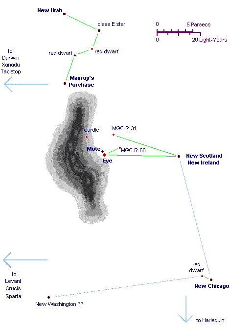
This map is a close-up of the Trans-Coalsack Sector and the region nearby. The Locations of the Mote, Murcheson's Eye, New Chicago, Maxroy's Purchase, and the New Caledonia system (which includes New Scotland and New Ireland) were discussed above.
The shape of the Coal Sack in this drawing, as well as the location of the "curdle", are based on the map in The Gripping Hand, (slightly modified to indicate that as seen from the Mote system, the Eye is seen with one edge of the Coal Sack as its background, as indicated on Mote 105, 154.)
As in the previous map, green lines represent single jumps and blue lines are more indirect routes. In particular, the route from New Chicago to New Cal involves several jumps (Mote 32, 36).
Additional stars:
- MGC-R-31 is a red dwarf 8 light-years from the Mote. MGC-R-60 is another red dwarf which is almost certainly closer to the Eye. ("MGC" stands for "Murcheson's General Catalog".)
- Maxroy's Purchase is on the other side of the Coal Sack from the Mote (Hand 9, contrary to the Hand map). The route to New Utah passes by two red dwarfs and a "class E" sun (Hand 21; Outies 59). Heading back towards the Empire from Maxroy one encounters Darwin, then eventually Xanadu and Tabletop, which are CoDominium worlds near the center of the Empire (Hand 12).
- Harlequin, an extremely primitive world, lies past New Chicago, since Sally Fowler stopped here on her way to investigate Harlequin.
- There is a red dwarf 0.4 light-years from New Chicago which Rod Blaine used to stage his attack ("Reflex" 16). Most likely this red dwarf orbits New Chicago's primary sun, which means that the Alderson tramlines will change as the smaller star slowly changes its position.
- One reference suggests that New Washington is only one jump from the red dwarf, but other texts make this seem unlikely. See below for details.
- Levant, Crucis, and Sparta are back towards the heart of the Empire. Some texts seem to imply that Crucis and Levant aren't far from here. (See "Motelight" 118, Hand 139)
Also, the flare star EST 1310 is located "Galactic South of the Coal Sack", but no specific distance is given. (WWII 177, 197, 213.) It's not on this map, since galactic north and south are towards and away from the viewer from this perspective.
New Washington and the Size of the Empire
The extent of human settlement in the galaxy grows as time progresses, at least up to the end of the First Empire. The Second Empire seems to be merely retaking old territory; they may not be founding new colonies at all.
In the 2080's, the CoDominium is 200 light-years in diameter, and contains 70 human colonies, according to FL 297 and WWFR 29. There are variations on these figures: WWFR 73 refers to "seventy-plus known stars", FL 211 mentions "nearly 100" inhabited worlds, GTS 248 counts "more than 100" human colonies, WWFR 209 refers to "ninety colony worlds and twenty affiliated planets", and PS 2 counts over 110 ("more than 40" founded in the first generation and "more than 70" in the second). The Mote prologue claims there were "200" colonies by the end of the 21st century.
In 3017, the Second Empire includes at least the entire 600 light-years from Earth to the Coal Sack. Mote 458 says that "everyone within two hundred parsecs wanted a seat on the Commission." In 3029, Horvath says the Empire contains "fifteen million cubic parsecs", which makes it about 1000 light-years in diameter. (Mote prologue.)
Horvath also mentions that the Empire contains 200 worlds in the year 3029. In 3046, Jennifer Banda says the Blaine Institute has specimens from 400 Imperial worlds and 30 Outie worlds. Also in 3046, Renner refers "1000 worlds", but this may be an exaggeration. (Mote prologue; Hand 73, 83.)
Despite slight variations, these numbers are roughly consistent. And all the planets mentioned during the 21st century are relatively close to Earth -- with one possible exception: New Washington.
- The plot of the final section of Falkenberg's Legion hinges on the fact that New Washington (and its companion-planet Franklin) is extremely far from Earth and the center of the CoDominium (see especially FL 432; Prince 609).
- According to PS 166 (Prince 986), the journey from Tanith to New Washington takes four months. Since Tanith is only one month from Earth, this means that the journey from Earth to New Washington must take somewhere between three and five months, making it a relatively close colony world.
- Travel time from Sparta to New Washington is given variously as "five months" (GTS 95; Prince 679), "eight months" (PS 8; Prince 870), and "nine months" (PS 166; Prince 986). The nine-month figure appears in an almanac table, and is perhaps the most reliable. Moreover, the Sparta-New Washington route goes via Tanith, and (as noted above) the Sparta-Tanith trip takes five months and the Tanith-New Washington trip takes four, so this supports a figure of nine months (or perhaps eight, since the ship need not enter Tanith's gravity well).
- According to GTS 249 (Prince 788), New Washington is 20 light-years from Sparta. This is quite close. Indeed, as the route from Sparta to New Washington passes through the Tanith system (PS 166; Prince 986), we would expect that New Washington is even closer than this to Tanith, and probably to Earth as well.
- The diameter of the CD is 200 light-years (see above). New Washington is mentioned as a particularly distant world. So we might expect it to be between 50 and 100 light-years from Earth.
- According to "The Battle for New Washington", the route from Earth to New Washington involved "a chain of Alderson Tramlines that was long and, once one left the core, uninhabited" (WWRW 238),. This story also reveals that the stellar system containing the planets Franklin and New Washington is known as "the Chesapeake System".
- On FL 432, New Washington is explicitly said to be 100 parsecs from Earth. This is around 330 light-years, which is farther than any CD world ought to be.
- Moreover, on Hand 366, we are told that before the assault on New Chicago in 3016, the Fleet gathered at New Washington "before the final jump". Since "Reflex" establishes that the fleet jumped to New Chicago from an uninhabited red dwarf system 0.4 LY away, the simplest interpretation is that New Washington is one jump from this red dwarf. But New Chicago is in the Trans-Coalsack Sector, 65 light-years from New Cal – which is itself 37 light-years behind the Coal Sack. The Coal Sack is around 550 light-years from Earth. So New Chicago is between 500 and 650 light-years from Earth. There is no precedent in these tales for a single Alderson tramline 200 light-years long, so if we accept that New Washington is one jump from this red dwarf, then it must be quite close to the Coal Sack -- which is impossible for a colony founded in CoDominium times.
I don't have a good resolution to this problem. I tend to disbelieve the "one jump from New Chicago" version, however. Perhaps the fleet assembled at New Washington before the final series of jumps?
There is one other piece of data that suggests a CoDominium much larger than 100 light-years in radius. In The Battle of Sauron (second edition) chapter 33, it is stated that Betelgeuse is 180 light-years from Haven. Since Betelgeuse is between 500 and 800 light-years from Earth, this would put Haven at least 300 light-years from Earth, which contradicts the data mentioned above.
Appendix: Astronomy Books and Web Sites
First, some written references:
- Peter van de Kamp, "The Nearby Stars", Annual Review of Astronomy and Astrophysics, Vol. 9, 1971, pp. 103-126.
- W. Gliese, "Catalogue of Nearby Stars", Veroeffentlichungen des Astronomischen Rechen-Instituts Heidelberg, No. 22, 1969.
- W. Gliese and H. Jahreiss, Third Catalogue of Nearby Stars, in preparation. See web-site below.
- Ian Ridpath, Norton's 2000.0, Longman, 1989.
- Cambridge Atlas of Astronomy, Cambridge University Press, 1994. This contains the map at the top of this page and many beautiful illustrations.
- James Binney and Scott Tremaine, Galactic Dynamics, Princeton University Press, 1987. If you would like a description of the motion of stars in our galaxy, this is your source! Some background in math and physics won't hurt (this is a standard first-year grad school text).
And some on-line references:
Also, you can buy the Yale Bright Star Catalogue, 5th Edition (Hoffleit, Warren 1991), but it doesn't seem to be online anymore.
Jerry Pournelle's Future History . . . . . Star-Map
Updated 15 May 2023 by Larry King
Back to the Future History Page
Home to the Science Fiction Timeline Site 
 Send email to Larry King